


The story of the South Campus Runoff and Pedestrian Project starts way back in the mists of time. Well, 1964, anyway.
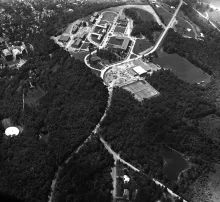
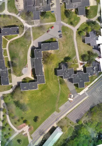
SUNY Oneonta was getting ready to massively expand from its 1948-1962 building phase: Golding, Lee, Morris, Alumni, Littell, Wilber, Tobey, Chase, Human Ecology (then called Home Economics, but never mind) and the Heating Plant. The idea was to develop a much larger campus intended to absorb the Baby Boomers. Your grandparents. Who, in 1964, were probably still tenth graders. They developed a plan to carry the development all the way into 1972, since eight years was all anybody could reasonably look ahead to. We think they assumed that growth would continue and that Hunt Union would actually be the center of campus. Didn't work out that way. The plan involved a somewhat harsher approach than we are used to today. They basically came in with giant bulldozers and swept clean the old-growth forest and all the wonderful soils.
Still makes us ill to look at this image. Anyhow, they built twenty buildings, and a bunch of parking lots, sidewalks and concrete staircases to go with it. This stuff is all, by definition, impermeable to water, being rooftop and pavement and such. Plus the soils that were left behind after the construction spree were simply awful - clays and rock rubble. The solution to this problem - what to do with the hundreds of thousands of gallons of rainwater that came with every shower - was to construct an elaborate network of storm drains.
This includes roof drains and piping, surface catch basins in roads and parking lots, drop inlets in lawns and foundation drains around every structure. Plus miles, and miles, and miles of progressively larger pipes to accumulate all of the runoff and conduct it off the east and west flanks of the campus. All to end up in Silver Creek (west) or Oneonta Creek (east) and thus to the Susquehanna River. The which river, by the way, wends its way through New York, Pennsylvania and Maryland to empty said rainwater into the Chesapeake Bay and the Atlantic Ocean, 440 miles distant.
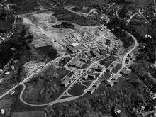
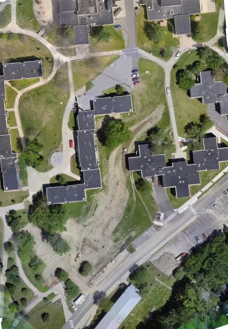
It all worked as advertised and as designed. Except... Over the next forty-five years, we added stuff. We added new buildings (Hunt, Milne). More parking lots. More and wider sidewalks. Paving bricks. Tennis courts. Another dorm. A Field House. Yet another dorm. We added pitched roofs to Golding, Littell, Tobey and Wilber. We made existing buildings bigger (Fitzelle, Physical Science) and started converting athletic fields to artificial surfaces.
All of which added up to a steadily increasing volume of stormwater that had to be dealt with by the same old 1964-designed system.
On top of which... the climate started to change.
You see, the engineers who designed the stormwater system during the Johnson Administration used climate data from 1930 - 1960 as the basis for calculating the likely intensity of rainfall and consequently the kinds of pipe diameters and structures to contain and conduct it.
But now we are getting more and more events of extreme, short-lived but very intense rainfall. And the storm system could not handle it. We'd get a storm that would drop an inch of rain in ten minutes, and all over campus we would have hundred-pound manhole covers blown right off by the backed-up water. Plus more mayhem downhill.
Something had to be done.
So... in 2015 we wrote a grant application to the tune of $900,000 to the NYS Environmental Facilities Corporation for the Green Infrastructure Grant Program. And to our utter astonishment, we received an award.
This kicked off a lengthy project sequence to evaluate the problem, carry out engineering analysis, develop a design, go through a year's worth of review, changes, redesign, acceptance, project bidding, contract awards... all leading up to the start of construction in May 2017.
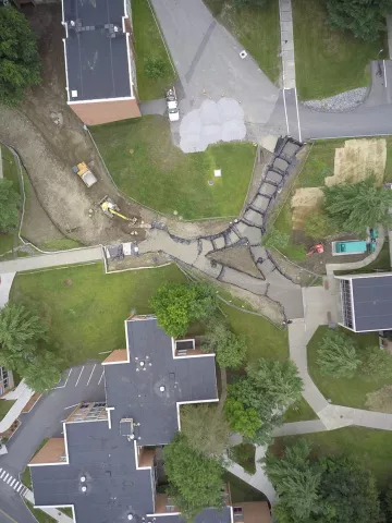
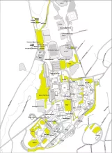
The whole point of this was to bring a portion of the stormwater flow to the surface, allowing it to accumulate in the basins, be absorbed by soils and plants, and for some of it to be allowed to absorbed into the ground instead of rushing off campus into the nearby Oneonta Creek.
Another component of the project is a pedestrian pathway connecting East Dorm Drive (where Golding, Lee and Littell are) with the Wilsbach/Mills - Dining part of campus. The goal was to create a pathway that met accessibility requirements related to slope (less than five percent, which means that it rises / descends less than one inch in twenty inches of horizontal travel. In this case, we met that by designing a route that is 600 feet long but ascends smoothly just 18 feet vertically, for a slope of 1:33, significantly less than the maximum permissible.
This not only offers an accessible path for anyone in a wheelchair or other wheeled conveyance, it is a great deal more pleasant to walk on for everyone.
The other new feature of this sidewalk is that its surface is composed of permeable pavement. This is a special asphalt surface that allows water to flow directly through the surface into drainage underneath it, as opposed to running off the surface and eroding soils.
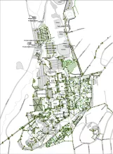
The project is now mostly complete, with plantings to populate the bioretention basins, engineered-blended soils, and grass filling in the bare hillslopes.
Meanwhile, heavy rainfalls demonstrate the system's function: water gushing into the second bioretention basin.
Once it begins filling, it also fills the third basin and this one overflows, as designed, down a set of cascaded stone blocks and into the fifth basin.
We will post more details about this project as we go along, and add information about how the whole system is functioning.
Rachel Kornhauser - Office of Campus Sustainability - rachel.kornhauser@oneonta.edu